Study Area Map
Our map of the Macoun Field Club's Nature Study Area
This map has been developed out of the series of vegetation maps that Macoun Club members began drawing up in 1972. Though dated 2008, it was updated in 2012. Our Study Area covers about 800 acres, or 300 hectares, within Ottawa's western Greenbelt (Stony Swamp).
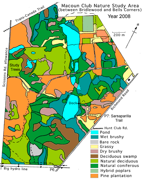
Important features revealed by this map:
- The straight boundaries
- The wetlands
- The sometimes straight divisions within the area
- The often irregular divisions between vegetation types
- Where the Study Trees are, in the west
- The observation dock on the big pond, part of the Sarsaparilla Trail
What these features mean
-
1. Boundaries, and what lies beyond them.
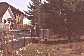
The sharpness of the Study Area's straight boundaries shows that they are manmade, rather than natural. They range from old wire fences through the woods (in the north) to foot and bicycle paths (on the west and northwest), and highways (Richmond Road, on the east). The northeast border is medium density residential area behind a low chain-link fence (Bells Corners). Extensive natural habitats continue beyond our boundaries in the north and south, and in the east. In the west, a vast new urban area of 20,000 people (Bridlewood) lies only 100 to 300 metres away.
The picture at right looks southeast across the old farm lane that was the main access route in the 1970s, which ran straight in from the Richmond Road/ Moodie Drive intersection.
Links with various trail systems (Rideau Trail, Trans-Canada Trail, Greenbelt skiing and hiking trails) bring hundreds of recreational users into the area every weekend. Public and personal access points also allow nearby residents, their dogs, and their cats to enter daily.
-
2. Wetlands
Most of our wetlands are beaverponds, which generally date back to the re-establishment of beavers here in the early 1960s. Some of these wildlife-rich ponds have grown in extent as dams are raised higher and made longer. Others have proven unsustainable, either in terms of food for the beavers, or water flow to fill the ponds in all seasons. As the beaver exhaust their food supplies around one pond, they seem to move to another, and then back again after a while. In any given year, there are seldom more than three active lodges among the ten beaver ponds. Water levels may drop for extended periods where the beaver are not maintaining the dams. This has been the case with Pond I, at the Sarsaparilla Trail, since 1998.
As well as expanses of open water about a meter deep, the beaver ponds include cattail and Purple Loosestrife marshes, willow and dogwood thickets, and stands of dead, drowned trees. (Most of the dead trees other than White Cedar have rotted out and fallen into the water since the 1970s.) The biggest pond also backs up into the extensive White Cedar and Black Ash swamps in the south, so that they are not so dependent on seasonal water flow.
A few ponds, mostly on the western side of the Study Area, are entirely seasonal. They occupy shallow depressions in the landscape, and fill with snow melt, and drainage through the ground in wet periods, but dry up completely in summer. Around their fringes are forests of certain kinds of trees that can tolerate, or even thrive on seasonal flooding. These are swamps of Red and Silver Maple, and Black Ash.
-
3. Internal division by straight lines
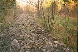
At left is a low pioneer stone wall almost 3 m wide, and hundreds of metres long. It once divided pasture (which naturally came back as juniper and spruce) from cultivated land, which was eventually put into pine plantations. The old, now grassed-over farm lane runs along the right-hand edge.
Land ownership and land use patterns a hundred years ago also determined the the shape of the main body of natural deciduous forest, which includes our study trees. This land was cleared, but never plowed, as shown by the very hummocky ground. What are now pine plantations immediately to the south and the northwest were, however, fields that were intensively cultivated until about 1950.
-
4. Internal division by landscape features
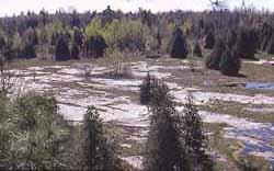
Irregular divisions between vegetation types generally relate to small scale features of the landscape. The wetness of the ground is one major determinant of vegetation. Soil depth is another. Open patches, dry brushy areas, and seasonally wet zones occur where the soil is very thin; forest where it is thick. In one place in the south, there is no soil at all, and acres of absolutely bare, glacially marked sandstone are exposed.
-
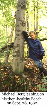
5. Where to find your Study Tree!
Macoun members all choose one or more 'study trees' in one small part of our overall Nature Study Area, a 10-acre hardwood forest. This was originally designated the 'Bridlewood Impact Study Area,' (B.I.S.A.) back in 1988, but it has yielded so many observations that are not related to urban development at all that we have renamed it "the Study-Tree Woods." We do not mark the trees in any way, but endeavour to recognize them as individuals and learn the landmarks the way a wild animal would learn its home range. And we follow them long after their "owners" have moved on in life. Twenty years later, Michael's American Beech is in declining health.
-
6. The Sarsaparilla Trail observation dock
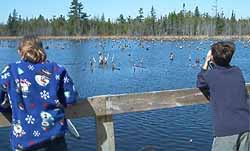
With input from the Macoun Club, the trail system and dock were built in 1973. This is a popular spot for families, and for people walking their dogs. It was designed for wheelchair use. It doesn't connect up with any other trails, so there are no bicycles.
At right, Macoun Field Club members Kathleen and Johnny on a field trip to the dock. On that occasion, a pair of Ring-necked Ducks had just been sighted swimming along the opposite shore. In September, 2012, we watched three Great Egrets fishing in the same area.