Black
Donald
Lock 21
Lock 22
Lock 23
Eastcliffe Hall
Mille Roches Powerhouse
Moulinette
Hoople Creek Bridge
Links to
other sites
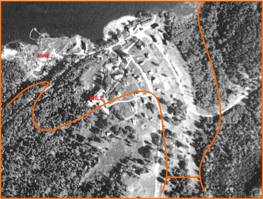
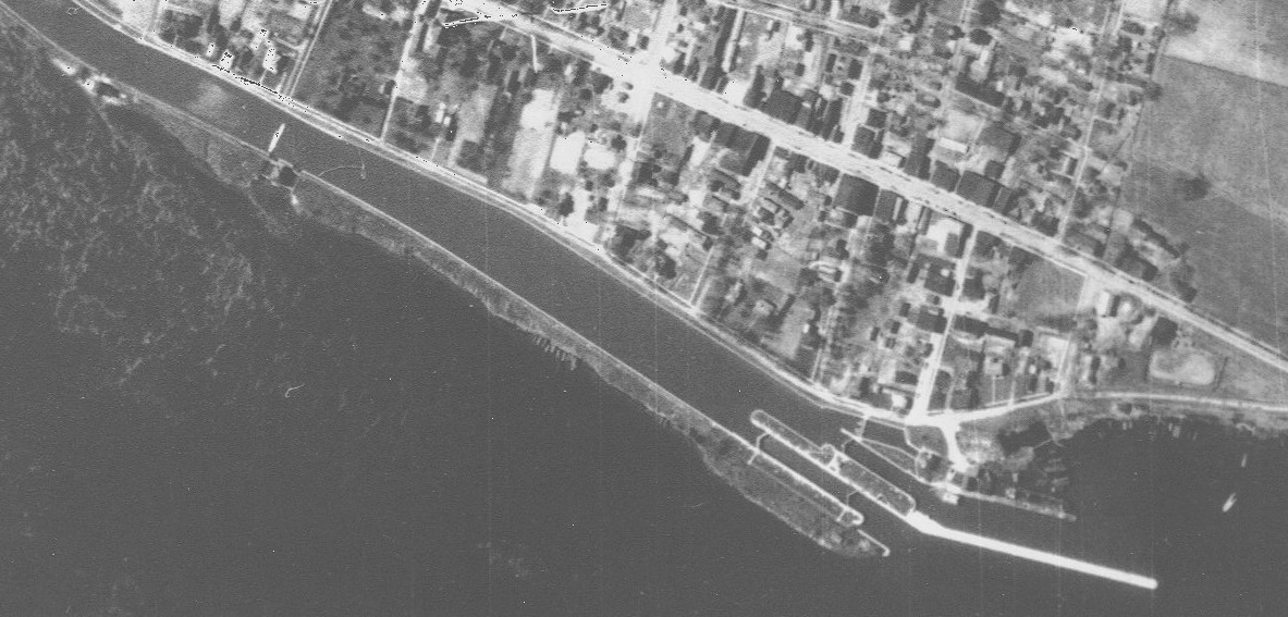
This map is of Black Donald. It is a sunken graphite mine town, shown above as it was in 1951. The curved lines represent the current shore line, the bar at the bottom a barrage. The new water level is about 45 feet higher than the original lake.
The history of the town is described in : http://www.ottawavalley.org/tours/ovexcursions/ss_pg.html
From 1895 to 1954, the Black Donald Graphite Mine was one of the richest in the world, and the only one in North America to produce high-quality graphite suitable for lubricants. During peak production, post World War I, the mine accounted for 90% of all the graphite extracted in Canada. Named after local lumberman, Black Donald McDonald, the mine suffered its share of disasters. In 1901, lake waters rushed into the workings, and in 1917, fire destroyed the mill. Although the mill was rebuilt on higher ground, lake water damaged the workings again in 1950. Production ceased in 1954, and in 1967 the headpond of Ontario Hydro's Mountain Chute dam flooded the site one last time. Today, a ghost town of some sixty buildings lies under the waters of Black Donald Lake, west of Calabogie.
Here are a couple of reports of the dives we did there:
We now have found another photo, from 1958, which shows the mine, which can be seen in the photo below. It is the BIG HOLE, probably 350 feet deep, although this is to be verified, and 300 by 700 feet. This map is not to the same scale so you can see the size of it. Best advice when diving this site is to not cross the lakeside of the sunken road, there is nothing there - LITERALLY.This is a well known, but infrequently diven, site in Eastern Ontario.We explored a new dive site and the visibility made it an extra adventure. The site is that of a submerged (hydro dam project) graphite mine town. Our directions even to the dive site were sketchy, let alone our comprehension of the dive site.
We were hoping to find the mine, but just exploring the building foundations was fun.
BTW It was also great buoyancy control training as at those depths with a dry suit, a fraction off blows it all away...... AND we didnt kick up silt.
6 foot viz, 32 feet max, 60 minutes, 52F.
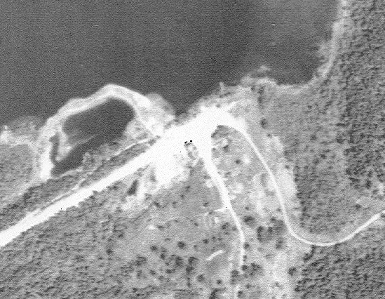
Another dive today at Black Donald. This time, we equipped ourselves with an arial photograph of the town and mine, taken in 1951.
On arrival at our site, we spent a very pleasant half hour talking with our hosts about the town which they had lived in for generations. We discussed the map and history of the town. They brought out a book on Black Donald and its inhabitants.
The mine was flooded and destroyed by the lake breaking through, most likely after 1951, the year of our photo. Apparently, after this disaster (people were killed), the mine was continued as an open pit mine.
The town was flooded in 1967.
The main mill building is just by the edge of the lake now, it is big but only foundations and heaps of rubble remain.
We dove out to the submerged road, discovering a building not on our photograph on the way. We then explored the other side of the road where we were told the 350 foot deep pit was. We hooked up a line on a tree stub and voyaged outward ... and downward. The last tree stubs were seen at 45 feet, so I guess that represents the old lake level. Given the 6 foot viz, we called off that particular exploration at 65 feet ... quite scary but what an adventure! We currently do not know the dimensions of the pit but apparently a coffer dam was built on the lakeside of it. We have so far not found any other mine shafts, although there are supposed to be, or at least were, several scattered around the town.
We returned to the submerged road and followed 10 foot spaced posts on the lakeside of the road. We spent some time going along here but not to the general store, which was maybe another 300 foot along the road.
We returned Southward towards the shore, discovering more buldings, some of which we saw on our first visit. One of the new ones contained some large iron tubes, possibly old steam pumps or boilers.
This is another example of the fresh, warm, but not visible, diving in the Eastern Ontario region. It was a lot warmer in the water, at 50F, than on the surface, at 30F. In these conditions, one is reluctant to remove the dry suit :-)
This is an advanced dive due to the low visibility, a compass is essential equipment here. The potential for great depth and, possibly, dangerous holes should be a caution to anyone.
Also, access is through private property and anyone who might consider this dive should be very well behaved and seek permission of the property holders, we would not like to see them abused for their generosity.
75 minutes, 65 foot max though most was at around 20 foot.
This map shows the area around Lock 21. It dates from the turn of the century. The blue area represents the original water levels and the green areas represent the current land. The white areas represent flooded land.
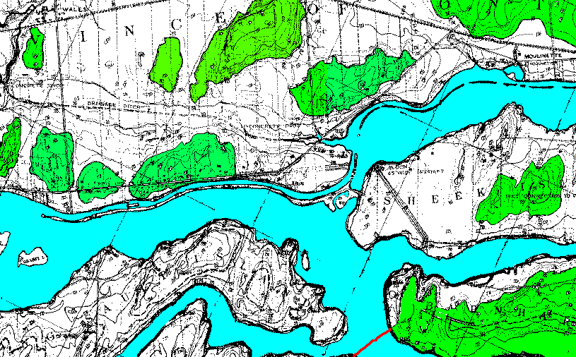
Lock 21 is visible to the left of centre, just off the tip of the island. At the left edge is the old Dickinson's Landing. You can see that one could happily do a ten minute drift down the canal from Lock 21 and still exit on the island. More interesting is the old barrage further to the East. I haven't dove this yet; I'll try it one day with a boat. Further still to the East is the town of Moulinette. Another boat dive to be undertaken.
Entrance is from the left by the road. The green lines represent the current shore line. Of great intererst on this site is the outer front lock gate, which is still upright and in place.
Current on this site is strong and if you wish to return to the entry point, you must either haul yourself along lines laid by your's truly and others or swim North-West where you will rise to 10 feet and be out of current. You can then easily swim back or even walk out in the shallows.
Depth is roughly 30 feet and 55 feet, current 1-2 knots and more in places.
This is of course directly in front of Morrisburg. Just park in the modern parking lot by the jetty and jump in. It takes a couple of minutes to swim out over the shallow part to the lock proper. Exit is downstream by the beach and washrooms.
Conversely, you can enter upstream by the New Pump
House. A trip over the canal and you can visit the Old Pump House remains.
Drift down the outer side and you come to the hydro power station. After
this, drift along the canal for 10 minutes and then head in, you should end
up by the jetty.
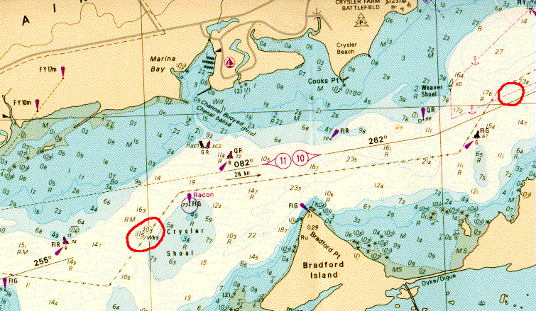
A dive in 2-3 knot current with 15 foot viz would not normally be considered good. But these are often the conditions on the laker Eastcliffe Hall, off Crysler Marina.
This map indicates the position of the wreck of the Eastcliffe Hall with respect to your boat launching at Crysler Marina. It is located by Crysler Shoal. Also indicated, to the right of the map, is the approximate location of another wreck. However, as this is in the shipping channel, it can only be dove out of season, which I have yet to do. Depths are given in this map in metres, one metre = 3¼ feet. They are also the minimum depths to be found; the Eastcliffe Hall lies in 60 feet. The wreck is normally buoyed but care must be taken, especially if you drift off the wreck, as it is right on the edge of the shipping channel. The ship is enormous, 350 foot long, and you traverse the vessel through the holds as they provide shelter from the current. The holds are cavernous and open and quite safe to swim through, just keep a patch of light in view, unless trained for wreck penetration.
Although I have had 45 foot plus of vis here, it generally has poor viz and often it is not possible to see the ship at all when in the middle of a hold. However, as one moves forward through the holds, forms slowly emerge. A trip to the screws and rudder is fun, leaping over the stern. The current immediately behind the stern is zero and low adjacent to the exterior hull.
PS. Do not do what I did on one dive here. Don't forget to take your gloves with you as those zebra mussels are sharp. Ouch, ooo, ee, ouch.
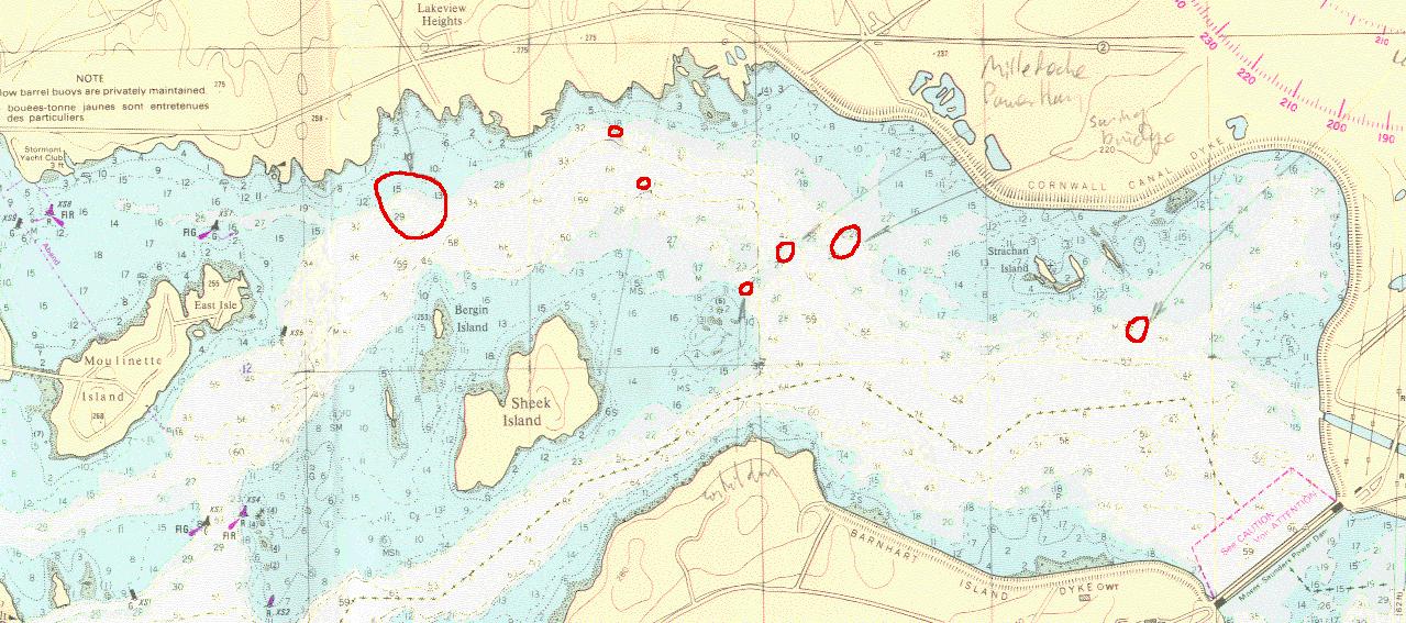
The above map shows the section of river between the hydro barrage at Cornwall and Lock 21, off screen to the left. The land here was flooded around 35 feet when the barrage was built; depths are given in feet and represent minimums, generally add another 20 -25 feet here.
The sites shown, from East to West, are Lock 20. This will be like lock 21 but deeper, about 75 feet bottom; it will have a current around 1-2 knots. I haven't dove this site yet though am hoping to this year. This should only be considered if you are extremely experienced due to its proximity to the barrage half a mile away. Next, to the left, is the swing bridge; I'll put a photo up later of the bridge before the area was flooded. Then comes the Mille Roches Power House. It still contains generating equipment but should only be penetrated with lines, lights and training. A picture of it before the flood is available on Jean Langlois' page. This, along with the next site, the control dam, are buoyed and always popular. As with most sites East of Cardinal, viz is around 15-25 feet, due to silt mostly, and the current is around 1 knot.
After having dove the Power House, a couple of short dives are relaxing. They are the Belly Dumper and utility barge, located by the two small circles 2nd and 3rd from the left on the map. Both dives are short as there is not a lot to see. The belly dumper is a dark site; the dumper has three hoppers in its hull for dumping, and lays on its side in 86 feet. You can swim through the middle hopper. Further inshore, in about 45 feet is what looks initially like an old jetty. In fact it is a utility barge; rectangular with flat ends, boiler and two steam winches. No idea what it is but it is fun exploring. Both these dives can be done on one 80 cubic foot tank.
Further West is the town of Moulinette, which I still
have to dive. There is also, as yet unmarked on the map, the schooner Cornwall,
which lies off Moulinette Island somewhere. I hope to dive this soon.
This is a new and interesting site. I first heard a
rumour of a lost tunnel in 2004. I got all available information I could
from The Lost Villages Society,
Ghostownpix
and The Stormant, Dundas & Glengary Historical Society
P.O. Box 773
Cornwall, Ontario K6H 5T5
Tel: 613-936-0842
Fax: 613-936-0798
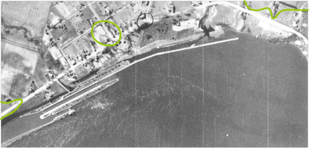
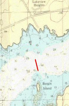
Referring to the above map, the site lies between
Lakeview Heights Park and Bergin Island; the causeway is shown by the red
line; the tunnel is at the North end of this line. Compare this with the
earlier map of Lock 21. That map was made around 1910 or 1920. As you can
see, there is no sign of anything.
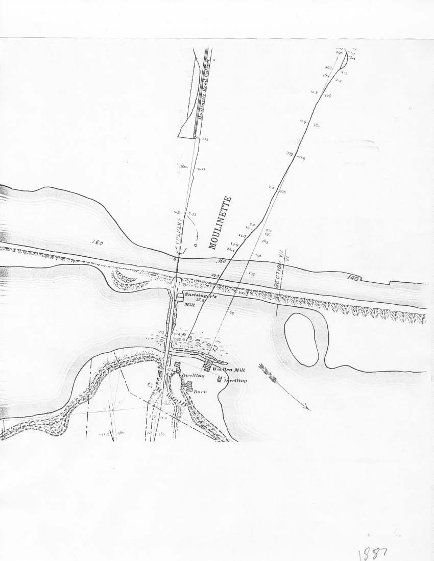
This map is in fact very accurate, except
for the number of bridged gaps in the causeway and also that it was created
before it was flooded. I have produced the following map that relates the
causeway to the Lock 21 map above.
 .
.
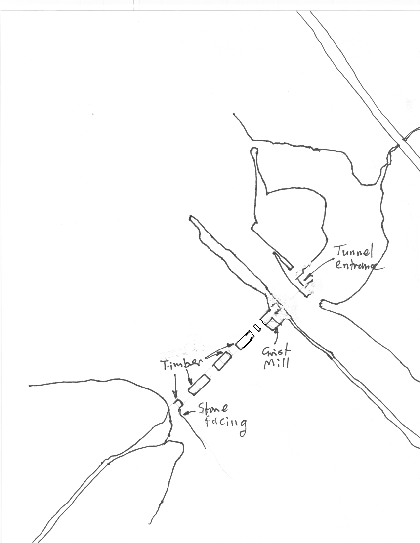
There are several major features, but
the one best used to locate all others is the causeway. This was constructed
over this branch of the river in the early 19th century. It was used to get
to Sheik Island to graze animals and to get to the woollen mill at the South
end. Following is a sketch of part of the causeway.
The causeway is about 250 feet long.
It was built over the narrowest and shallowest part of the river. Given it
is about 8-10 foot high, the water depth could only have been about 6 foot;
with the large rocks around, the river must gave been very similar to the
Ottawa river by the Champlain Bridge today. The causeway is constructed from
large timbers filled in with rocks and earth and a surface made on top. Today,
silt has filled in behind the causeway but the strong current has kept the
upstream side clear. It is about 15-20 feet wide. The low elevation of the
causeway makes it very difficult to locate with a depth sounder.
When the causeway is located, following
it North brings you to the Grist Mill. This is shown in this potograph,
taken from the causeway.
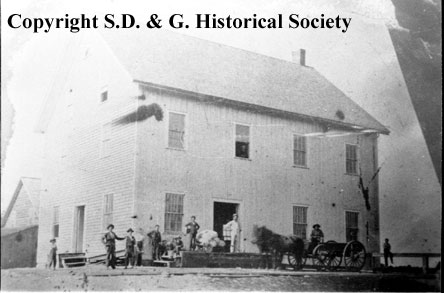
The first floor is complete and
the second floor remains up to the window sills. However, over 100 years
of silt and rubble have encroached on the lower 6 feet. Inside is not as
bad and there appears to be remains of the mill machinery; to be explored
further. Exploring the inside of the grist mill provides a nice respite from
the current.
Following the causeway further North, one arrrives
at the canal. This was the original canal, built mid-19th
century (does anyone have the actual date?).
It was 8 feet deep and, to allow access to the causeway and mills, a tunnel
was put underneath it at this spot. This tunnel still exists, with huge stone
faces and retaining walls. Once again, silt and rubble of over 100 years
has blocked the entrances.
Diving Moulinette
Standing in the park at Lakeview Heights and
looking South towards Bergin Island, a slim pointed island which is now home
to Cormorants, 2500 feet into the river, just slightly upstream is where
the tunnel is. This is not swimmable and even with a scooter, it is very
difficult to find due to current, visibility and navigational problems, the
bottom being confused undulations and silt.
On a boat in mid-stream, the causeway can be
found in a line between the end of Bergin Island and the red brick
building in the park. Once found, you must go upstream 300 feet to make a
free descent and drift onto the causeway.
The best way to dive this site is from Bergin
Island. From the tip, head straight North and down. You will come to the
upstream of the casueway or the channel at right angles to the causeway.
If the latter, which is more common, then just follow up the channel, or
far bank of it, and there is the causeway. If you turn downstream in this
channel, you come to the basement and ruins of the woollen mill, which aren't
so interesting.
Things to remember are: The original river bottom
is at a depth of 65 feet, and more downstream; the original land and causway
are at 55 feet; the post-1902 land at 35 feet and the canal itself around
40-45 feet in the bottom.
There is stiff current so be prepared to be picked up by boat after making a drifting ascent; a surface marker buoy is needed for this, as well as surface support in the boat.
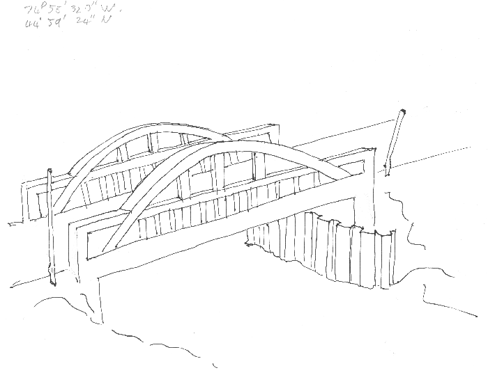
Here is a rough sketch and dive report of the bridge.
Eastern Ontario by Jean Langlois
Kingston Ontario Scuba Diving
Unofficial Ottawa/Hull/Cornwall SCUBA
Ontario SCUBA diving
Unofficial Scuba Quebec
Save Ontario Shipwrecks
Great Lakes Marine Museum - Kingston
Preserve Our Wrecks
Ontario diving
The town of Brockville
Prince Edward County
The Thousand Islands Chapter of the SOS
Daryl's Diving Service
Marcel Cossais' web page.